Plat of Survey (also called a Staked Survey)
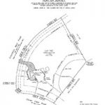
This is one of the most common types of surveys due to its wide range of uses. A plat of survey is used to depict the boundaries of a parcel using its legal description and physical evidence on the property. Todd Surveying will send a survey crew to your property to collect the necessary data. From this data, a scaled drawing is drafted which illustrates property lines, bearings, distances along these lines, and total acreage.
The survey will identify any encroachments that might exist, as well as show any improvements on the property, such as buildings, driveways, fences, pools, etc.
The survey crew will recover all property corners and/or reset any of the monumentation or markers at the corners or along the lines of the parcel, often in the form of iron rods, pipes, concrete monuments, nails in asphalt, or a cut cross in concrete.
A map or plat is then drafted from the field data to provide a representation of the parcel surveyed. This survey can be used by anyone from a homeowner to corporations for a wide range of purposes including, but not limited to: determining property line locations for municipal and county requirements, determining property lines for building structures, locating easements, and resolving property disputes.
Boundary Survey
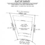
The purpose of a boundary survey is to establish or re-establish the extent of title lines and to define and identify those lines so as to uniquely locate each lot, parcel, or other specific land area in relation to well recognized and established points of reference, adjoining properties, and rights of way.
A boundary survey is a land survey that requires study, investigation, and evaluation of major factors affecting and influencing the location of boundary lines. A boundary survey culminates in the deliberate location or relocation of the perimeters, division lines, or boundaries of a certain lot, parcel, or quantity of real estate, according to the record title description of the parcel or parent tract. This description should be furnished by the client, unless otherwise jointly agreed upon by the client and surveyor.
Boundary surveys are also used to establish or reestablish boundary lines on the ground or to obtain data for constructing a map or plat showing a boundary line. These surveys are mathematically closed diagrams of the complete peripheral boundary of a site, reflecting dimensions, compass bearings, and/or angles. Each survey should bear a licensed land surveyor’s signed certification, and may include a metes and bounds or other written description.
ALTA/NSPS Land Title Survey (also called ALTA Survey)
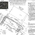
Title insurance plays an important role in protecting lenders’ and purchasers’ land investments. To be able to evaluate the property and the risks associated with issuing a title insurance policy on the property, a title insurance company must, in part, rely upon an up-to-date and accurate survey of the property.
An ALTA Survey verifies a legal description and possible easements of subject property. Additional items like planimetric and topographic data, utilities and site improvements, and zoning and hazard land information may be requested as outlined in Table A Items. ALTA Surveys are almost exclusively performed for multi-family residential, commercial, institutional, or industrial properties.
NOTE: MINIMUM STANDARD DETAIL REQUIREMENTS FOR ALTA/NSPS LAND TITLE SURVEYS (Effective February 23, 2021)
Attention is directed to the fact that the National Society of Professional Surveyors, Inc. (NSPS) is the legal successor organization to the American Congress on Surveying and Mapping (ACSM) and that the 2021 Minimum Standard Detail Requirements for ALTA/NSPS Land Title Surveys are the next version of the former Minimum Standard Detail Requirements for ALTA/ACSM Land Title Surveys.
Topographic Survey (also known as Topographic Map)
A topographic survey or map is the determination of the configuration, relief, or elevations of a portion of the earth’s surface, including the location of natural and/or man-made features thereon. A topographic survey is necessary in order to prepare an accurate topographic map and requires the expert skill of a registered professional land surveyor well versed in maintaining accuracy and precision in mapping. A topographic survey is not intended as a boundary survey, although some boundaries and locations may, by necessity, be defined; however, in some cases, at the request of the client, a topographic survey may be incorporated with one of the above mentioned boundary surveys.
The purpose of the topographic survey is to gather relevant information that will be represented on a topographic map. The topographic map is used by a variety of interested parties, such as land owners, engineers, architects, planners, developers, landscape architects, and governmental agencies for numerous uses, ranging from land use or development, to flood control.
The cost of the topographic survey will vary greatly depending on the size of the project, the accuracy requirements, and the intended use. It is imperative that the surveyor is made aware of the intended use of the topographic information, which will enable the surveyor to complete the project in the most timely and cost effective manner possible.
Site Plan with Proposed Grading
Builders, engineers, architects, and other professionals need to have visual representation of how their projects will fit within the confines of the subject parcel. Often times, if you’re planning to build a new home or put an addition on to an existing home, a site plan will be required by a building inspector or zoning administrator, so they can see exactly what you plan on doing with your property. All existing monuments can be located and relationships shown, but this is not a boundary survey.
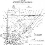
Flood Plain Survey
Flood plain surveys are used to determine whether a building, parcel, or a portion of a parcel near a body of water lies within the floodplain as determined by the government agency FEMA. This survey is most commonly requested by a mortgage lender, insurance company, or zoning department. If the subject property or structure is found to be above the established flood plain elevation, then a LOMA application or elevation certificate can be drafted with the help of a surveyor and an amendment made by FEMA to their floodplain mapping. Often times this survey can help in removing the requirement of costly flood insurance.
Flood Surveys
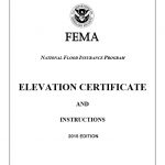
•Elevation Certification
•LOMA/CLOMA/LOMR-F/CLOMR-F/LOMC
•Base Flood Elevation Determination
•Flood Hazard Area Determination
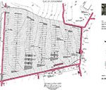
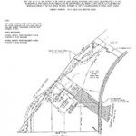
Subdivision Plat
This can be a requirement if a client would like to divide up a parcel into smaller parcels. At Todd Surveying we will work with the client and associated municipal entities to develop a plan that will be suitable to state and local statutes and will meet the client development goals.
Whenever the owner of land subdivides their property into two or more parts, any of which is less than 5 acres, he or she must have the land surveyed, and a subdivision plat thereof must be made by an Illinois professional land surveyor. If any city, village, or town has adopted an official plan, or part thereof, the plat of land situated within the area affected thereby must conform to the official plan or part thereof. (Requirements apply to plats of resubdivision, planned unit developments and consolidation.)
No subdivision plat is required in the instances outlined per the IL Plat Act Affidavit; however, the completed IL Plat Act Affidavit must be recorded with the deed.
ILLINOIS PLAT ACT AFFIDAVIT:
The Illinois Plat Act (765 ILCS 205) regulates the division of land. Whenever owners of land subdivide it into two or more parts, any of which is less than five acres, they must have it surveyed and a subdivision plat thereof made by the Illinois Registered Land Surveyor (765 ILCS 205/1(a)), unless any of the exceptions in the affidavit apply (765 ILCS 205/1(b)). If a plat is made by an Illinois Registered Surveyor of any parcel of land otherwise exempt from the plat provisions of this Act as indicated below, such plat shall be recorded (765 ILCS 205/1(c)). When a property is divided into parcels, so that it cannot be described without describing it by metes and bounds, it is the duty of the owner to have the land surveyed and platted into lots. The platting shall be in accord with the Plat Act. The plat shall be certified and recorded (35 ILCS 200/9-55).
Easement Plat
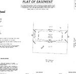
An easement is a right given to another person or entity to trespass upon land that said person or entity does not own. Easements are used for roads, for example, or given to utility companies for the right to bury cables or access utility lines. Landlocked home owners sometimes pay for an easement to cross the land of another to reach their home. Easements run with the land. Almost every home has an easement. It is important to look for easements in the public records, especially if a prospective buyer plans on adding improvements. A property owner cannot build on top of an easement.
Commercial & Residential Construction
At Todd Surveying, we can help a builder or developer with staking out their entire site from start to finish. We will coordinate with the general and subcontractors to stake all improvements including: grading, buildings, utilities, pavement, lighting, and much more, in a timely and efficient manner. We have worked on everything from huge commercial warehouses to small private residences.